For centuries, archaeologists have relied on painstaking excavation to unveil the secrets hidden beneath our feet. But what if we could peek beneath the surface without disturbing the delicate tapestry of history? Enter GPR scanning, a groundbreaking technology changing the face of archaeology.
GPR Scanning: A Window into the Past
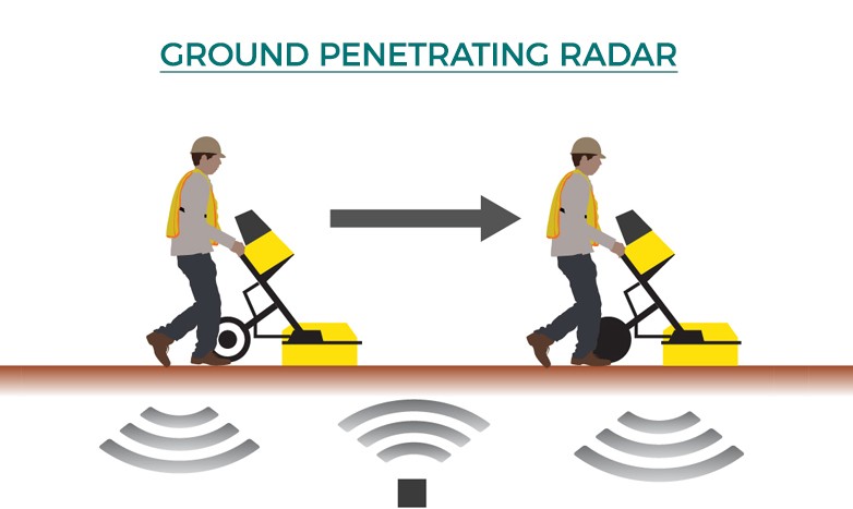
Ground Penetrating Radar (GPR) is a non-invasive geophysical method that uses radar pulses to image the subsurface. Think of it as an x-ray for the earth, allowing archaeologists to “see” buried features without lifting a shovel. This revolutionary technology is transforming archaeological investigations by:
Preserving archaeological sites: GPR eliminates the need for extensive digging, preserving the integrity of delicate structures and artifacts.
Increasing efficiency: GPR surveys can cover large areas quickly, identifying areas of interest for targeted excavation. This saves time and resources, making archaeological projects more efficient.
Unveiling hidden complexities: GPR can detect subtle changes in soil density and composition, revealing features invisible to the naked eye. This allows archaeologists to build a more complete picture of past landscapes and human activity.
How GPR Scanning Works: Peeling Back the Layers of Time
GPR utilizes electromagnetic waves to probe the ground. An antenna transmits high-frequency radio waves into the earth. These waves reflect back to the surface when they encounter changes in the soil’s properties, such as density, water content, or the presence of buried objects. A receiver unit captures these reflected signals, creating a visual representation of the subsurface.

Choosing the Right Tool: Antenna Selection for Optimal Results
Just like a carpenter selects the right tool for the job, archaeologists carefully choose GPR antennas based on the specific site and research goals.
Reconnaissance Surveys: Large-scale surveys, often used in the initial stages of an investigation, require antennas capable of covering vast areas efficiently. Vehicle-mounted antennas are ideal for this purpose.
Detailed Surveys: For smaller areas or when investigating specific features, higher-frequency antennas provide greater detail and resolution. These antennas allow archaeologists to map intricate structures and pinpoint the location of artifacts with greater precision.
Unlocking the Secrets: Data Processing and Interpretation
Raw GPR data resembles a complex, abstract painting. To reveal the hidden archaeological treasures, specialized software is used to process and interpret the signals.
Enhancing Clarity: Advanced algorithms remove background noise and enhance features, transforming raw data into clear, interpretable images.
Unveiling Patterns: Experienced interpreters analyze the processed images, identifying patterns and anomalies that indicate the presence of buried features like walls, foundations, graves, and even ancient pathways.
Integrating GPR with Other Methods: A Holistic Approach to Archaeology
GPR scanning isn’t a standalone technique. It works best in concert with other geophysical methods, creating a powerful synergy that provides a comprehensive understanding of archaeological sites.
Electrical Resistivity Imaging (ERI): ERI measures the electrical resistance of the subsurface, revealing differences in soil composition and moisture content. Combining ERI with GPR can help differentiate between natural features and human-made structures.
Magnetometry: This technique detects variations in the Earth’s magnetic field caused by buried metallic objects or features with different magnetic properties. Integrating magnetometry data with GPR results can pinpoint the location of metal artifacts, kilns, or other features with distinct magnetic signatures.
Advantages of GPR Scanning: A Paradigm Shift in Archaeological Practice
Ground penetrating radar scanning offers a multitude of advantages over traditional excavation methods, revolutionizing archaeological fieldwork:
Non-destructive: GPR preserves the archaeological record, allowing future generations to explore the past without compromising its integrity.
Cost-effective: By reducing the need for extensive excavation, GPR saves time and resources, making archaeological research more efficient.
Increased Accessibility: GPR can be used in areas where traditional excavation is challenging or impossible, such as densely populated urban environments or environmentally sensitive locations.
Challenges and Limitations: Navigating the complexities of GPR
While GPR is a powerful tool, it’s not a magic bullet. Successful application requires skilled operators and careful consideration of environmental factors:
Soil Conditions: Soil composition, moisture levels, and the presence of metallic objects can affect GPR signal penetration and clarity.
Data Interpretation Expertise: Accurately interpreting GPR data requires specialized training and experience.
Technological Limitations: GPR cannot penetrate certain materials, such as solid rock, limiting its effectiveness in some environments.
The Future of GPR in Archaeology: Expanding Horizons, Deepening Understanding
The future of GPR in archaeology is brimming with exciting possibilities. Advances in technology and data analysis techniques promise to further revolutionize the field:
Automated Data Analysis: Artificial intelligence and machine learning algorithms are being developed to automate the processing and interpretation of GPR data, accelerating research and improving accuracy.
Integration with UAVs and Robotics: Mounting GPR antennas on drones and ground-based robots will allow for faster, more comprehensive surveys, reaching areas inaccessible by traditional methods.
3D Visualization and Virtual Reality: GPR data can be used to create immersive 3D models of buried features, allowing researchers and the public to virtually explore the past.
Conclusion: GPR Scanning – A Revolution in Unveiling the Past
GPR scanning is transforming the field of archaeology, providing a powerful, non-invasive tool for exploring the hidden secrets of the past. By preserving archaeological sites, increasing efficiency, and revealing unseen complexities, GPR is paving the way for a deeper understanding of human history and the landscapes we inhabit. As technology continues to evolve, the future of GPR in archaeology promises even greater discoveries and a more profound connection to the stories etched beneath our feet.
FAQs about GPR Scanning in Archaeology
Can GPR be used to find specific artifacts, like pottery or metal objects?
GPR is not designed to directly detect specific materials like pottery or metal. It primarily detects changes in soil density and composition. However, if an artifact creates a noticeable disturbance in the surrounding soil, GPR may be able to indirectly locate it. Integrating GPR with other techniques like magnetometry (for metal) can be very effective.
How much does a GPR survey cost?
The cost of a GPR survey varies depending on the size of the area, the complexity of the site, the required resolution, and the experience of the operator. It's best to contact a GPR service provider for a specific quote based on your project needs.
Is GPR harmful to the environment?
No, GPR is a safe and non-invasive technology. It uses low-power electromagnetic waves that are not harmful to humans, animals, or the environment.
Can anyone use GPR, or does it require specialized training?
While GPR equipment is commercially available, effectively using and interpreting the data requires specialized knowledge and training. It's recommended to consult with experienced GPR practitioners for archaeological applications.
Are there any legal restrictions on using GPR for archaeological purposes?
Yes, it's crucial to be aware of and comply with all local and national regulations regarding archaeological investigations. In many cases, permits and permissions are required before conducting any geophysical surveys on archaeological sites.


